Result
Submit an address to run the lookup.
 Most Certainly Try
Nature work & public tools
Most Certainly Try
Nature work & public tools
Public Tool
Enter a U.S. address, choose the state, and get the matched latitude, longitude, and EPA terrestrial ecoregion levels.
Submit an address to run the lookup.
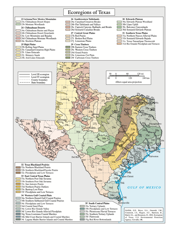
Texas reference map
This EPA map shows the state’s nested Level III and Level IV ecoregions—the same classification system used by the lookup above.
This page does not use a database, does not write to browser storage, and does not intentionally log submitted addresses.
Addresses are sensitive. Use a nearby intersection or landmark if exact-house precision is not needed.
The lookup uses public map services and returns EPA ecoregion attributes when the coordinate intersects a mapped polygon.
Address to coordinate
The request includes forStorage=false. The selected state is included to reduce ambiguous address matches.
Coordinate to ecoregion
The coordinate is checked against EPA terrestrial ecoregion polygons, with Level IV used first when available.
EPA ecoregions are nested from broad continental patterns to finer local ecological areas.
The largest ecological zones, shaped by broad patterns of climate, landforms, vegetation, and ecosystems.
Subdivisions of Level I that narrow the map by more specific climate, geology, terrain, and vegetation patterns.
The scale that is often easiest to recognize by name, describing a meaningful regional ecological landscape.
The finest mapped subdivision, reflecting more local differences in soils, terrain, vegetation, and land use.